PHOTO
66484.0
Progress continues on one of Cowra’s most complex infrastructure issues, with Council providing an update on the long-term West Cowra stormwater flood modelling project.
The project, which focuses on managing flooding through the West Cowra channel—particularly upstream of Grenfell Road has reached a key milestone, with modelling now updated to modern 2019 national standards.
Director of Infrastructure and Operations, Dirk Wymer, said the updated modelling represents a significant step forward in understanding how flooding behaves across the area.
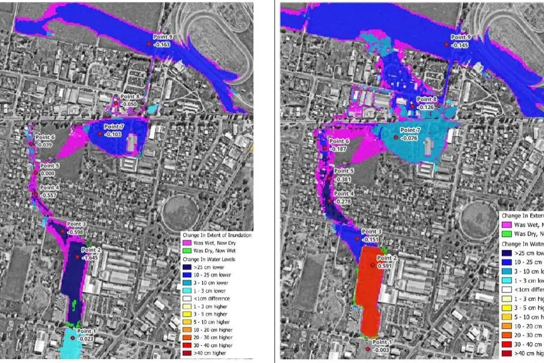
“The report provides a further update on the continuing modelling that’s being carried out on the West Cowra channel floodplain area,” Mr Wymer said.
“It specifically talks to the upgrade from the previous 1987 design standards and provides updated flow rates and inundation according to the newer standards.”
The updated modelling shows that while the overall flood affected land area remains similar, there are some changes in how water behaves.
Depth of flooding has slightly reduced under the new modelling, but peak flow rates have increased, highlighting the ongoing challenge of managing stormwater in a rapidly developing area.
Councillor Peter Wright said the flooding issues are closely tied to Cowra’s growth, particularly in areas that were once farmland but have since been developed into residential zones.
“There’s been houses built along different areas, and the drains that were there were probably from years when there wasn’t housing there,” Cr Wright said.
“Now, with more development, you get more runoff, and we have this problem in severe weather events of water accumulating.”
He noted that flooding in West Cowra can occur even without major river events, due to local runoff from urban development.
“We can get a flood event in this drainage system without there being flooding in the Lachlan River, just from the runoff of development,” he said.
Council is currently investigating a range of solutions rather than relying solely on large-scale infrastructure like detention basins, which have been found to have a low benefit cost ratio.
Instead, the focus is shifting toward more practical and targeted measures, including surveying properties at risk of overfloor flooding, investigating property level protections such as flood boards, considering alternative drainage designs, including pipelines and overflow swales and refining pipe layouts to reduce backflow and construction challenges.
One key proposal includes installing a 900mm stormwater pipeline through the Olive Grove easement, designed to better direct water flow toward Grenfell Road.
Mr Wymer explained that these types of solutions may offer more cost effective outcomes.
“Because of the high capital cost and relatively low benefit of a detention basin, we’re looking at other solutions, like flood-proofing properties or different drainage approaches,” he said.
The project has also highlighted the financial challenges involved, with large-scale infrastructure unlikely to qualify for certain grant funding due to its limited return on investment.
As a result, Council is carefully balancing cost, effectiveness, and long term planning as it works toward a solution.
“It’s a very difficult situation,” Cr Wright said.
“The runoff is very flat in some areas, then it moves quickly, so we have to control how water is managed without creating bigger problems downstream.”
With modelling now aligned to current standards, the next phase of the project will continue detailed investigations and design refinements.
Council will also carry out further surveys of affected properties and infrastructure.
Importantly, no construction work has begun yet, with the project still in its planning and modelling stages.
Mr Wymer said updates will continue to be provided as the project progresses.
“The intention is to keep providing councillors with progress reports over the next couple of months,” he said.